Many of us visit Aberdare for shopping and social purposes, but how well do we know and observe it as we walk around? This post reveals some of the histories of Aberdare Town Centre, including relics and buildings you can still see today.
*Disclaimer* Please do not use this as a guide to visit and walk around Aberdare if you are not local to the area. If you do undertake this walk, you must adhere to social distancing regulations.
Introduction
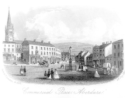
Until around 1800 Aberdare was a small village, the chief place of a poor agricultural parish, and the ‘very headquarters of solitude’ (B. H. Malkin, 1807). Its population in 1670 was estimated at 545 (Hearth Tax Assessments). It was however rich in minerals, and between 1757 and 1920s the local production of iron and then coal was responsible for its rapid growth into a large and prosperous market town. The first census of 1801 indicated the population of the parish was 1,406 rising to 55,000 in 1921.
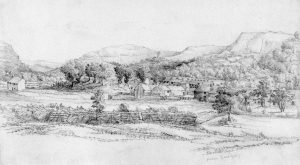
Aberdare in 1827 and then still a tranquil village. The Gadlys ironworks opened that same year and stood almost directly behind the artist. (‘Aberdare, September 3rd, by Emma or Lucy Bacon; ACVMS 1998.3418_002)
Starting at the library
This area in close proximity to St John Baptist, the parish church of Aberdare (Ca 1200), was the oldest inhabited part of Aberdare; here stood the original village and village green. The area was known as Green Fach (Small Green). It was the place of the market, a few inns, and a small row of almshouses built around 1720. These stood on the site of the library.
The village stocks were located in the churchyard.

The Green Fach area (OS)
In 1841 Green Fach was described as the most densely populated part of Aberdare, and in 1853, at the time of the Rammell Health Report, one of the worse quarters of the town.
The housing at Green Fach consisted of Green Street, Gadlys Row, Dare Place, Dare Street, and Chapel Court. These streets contained a large number of houses, crowded together upon a very limited space. (Rammell)
Aberdare Urban District Council Offices (RCT Library Service)
Two fine non-conformist chapels stand in the area; Green Street Methodist Church built in 1841 and Siloa Congregational Chapel dating from 1844, both in the classical style. Siloa was the scene of one of the most turbulent incidents in the town’s history being the venue, in 1848, of a public meeting held to object to statements published in the Blue Books. Note the plaque attached to the façade of the building. This records that fifty-seven people left this valley to set up a Welsh colony in Patagonia, South America in 1865.
The large building which houses Bradley’s Coffee House was originally the market house. Assembly rooms erected in 1832 and later used as municipal offices where meetings of the Board of Health were held. A third storey was subsequently added and after 1894 the Aberdare Urban District Council met there.
Proceed along Canon Street
Canon Street takes its name from the clerical Canons of Gloucester Cathedral whose Dean and Chapter had owned the land on which it stands since the Reformation.
The impressive Wedgwood blue building on the left is the Constitutional Club dating from 1894. Note the enormous open ironwork crown surmounting the building. It is a grade II listed building and once housed an Edwardian Music Hall, The Palace Theatre of Varieties, later re-named the Empire. The building has recently been restored and the original clock, long missing, replaced by a replica.
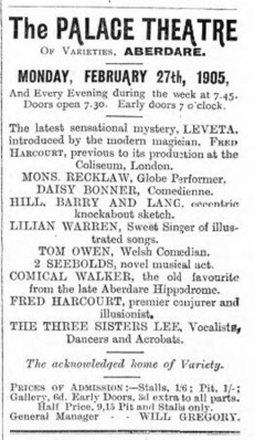
Aberdare Leader advert for the Palace Theatre, 25th February 1905
The stone chapel-like building on the right-hand side of Canon Street is the Masonic Hall (1880). On the left, the now closed Trinity Presbyterian Church dates from 1867.
The large convenience store on the far side of the junction of Canon Street and Weatheral Street stands on the site of the recently demolished Temperance Hall built-in 1858. It served as the town’s public hall and theatre with seating for 1,200 patrons. It was later renamed the New Theatre and Hippodrome, and finally, the Palladium when it became a cinema in 1918.
The gabled building, left, was the town’s public hall and theatre. (RCT Library Service 01b032)
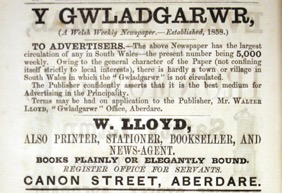
Advertisement for Y Gwladgarwr
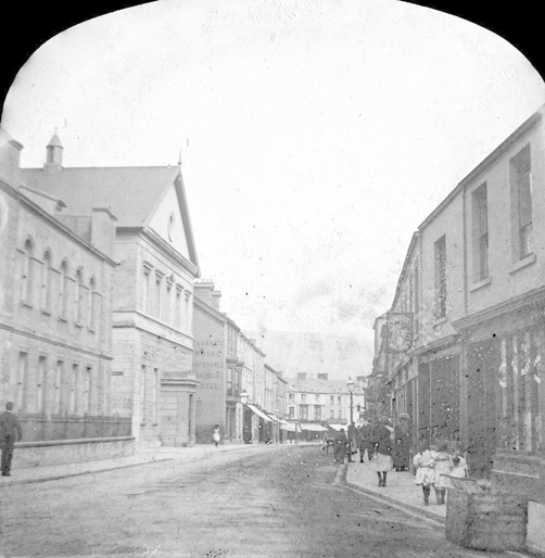
Burton’s the outfitters, at the junction of Canon Street and Whitcombe Street was originally the Queen’s Hotel (1861-1923). Opposite you will see the Halifax Bank, these premises once housed one of Aberdare’s many printing offices – there Y Gwladgarwr (The Patriot), the Liberal Welsh language newspaper was printed (1858-1882) by Walter Lloyd. Other periodicals were also produced there.
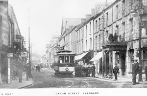
Canon Street. Right, the Queen’s Hotel, now Burton’s. Trams came to Aberdare in 1913. They ceased running in 1935. (RCT Library Service 01/b/012)
Commercial Street and Market Street
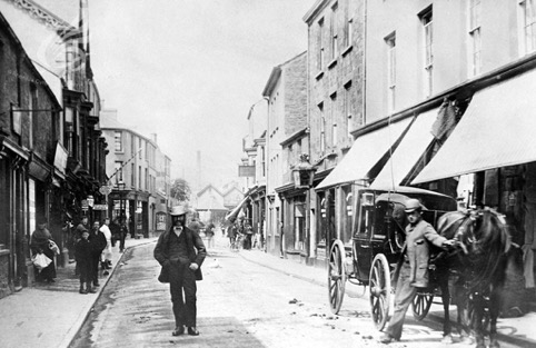
The broad area fronting The Works, used to be known as the Welsh Harp Square, after the public house of that name.
It was the location of one of the town’s many Hansom cab stands.
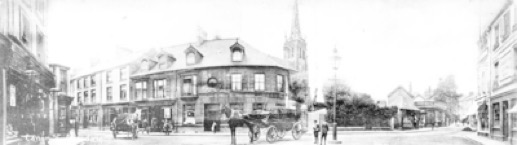
Welsh Harp Square (RCT Library Service)
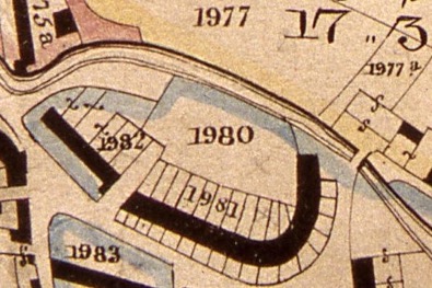
This section of the tithe map (1846) shows the river Dare running west to east above parcel 1980 and the Welsh Harp Bridge crossing into parcel 1977. St Elvan’s now stands on 1980. (OS)
The open river Dare, now culverted, was crossed by a bridge near this point. The bridge became known as the Welsh Harp Bridge and was once a focal point for ‘lounging, idle workmen’.
Proceed down Commercial Street
This short street was once the location of 15 public houses. Only one of the original hostelries now remains.
Commercial Street (RCT Library Service)
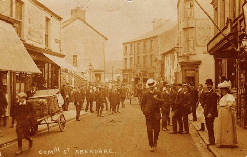
Sepia view courtesy of Mr Gareth Thomas. Five pubs can be seen in this image, the George, Railway Bar, Market Tavern (The Duke’s), Commercial and Iron Bridge.
Commercial Street ended at the river Cynon once crossed with a dangerous wooden bridge called Cynon or Trap Bridge. This was replaced with a latticed iron one in 1853. There were two large pubs on the town side of the river crossing, the Commercial and the Iron Bridge.
The road to Abernant was the ancient (and only) road to Merthyr, crossing the desolate mountain and descending at Heolgerrig (Stony road).
At the town side of the pedestrian foot bridge crossing the by-pass, the river Dare can be seen joining the Cynon. This feature gives the town its name – Aberdare, the confluence, or mouth of the Dare.
Look up, and to your left, you see the Valleys Line railway station to Cardiff. This was originally the Aberdare Station of the Vale of Neath Railway (opened September 1851) from Neath to Aberdare. The line was subsequently extended to Quakers Yard and Pontypool Road.
Walk along Duke Street
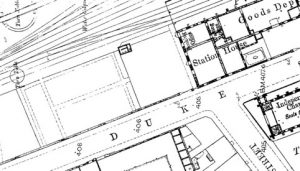
Duke Street (OS)
At the end of Commercial Street, turn right. The town bus station (left) stands on the site of the Taff Vale Railway station to Cardiff. The line opened in 1846 as the Aberdare Railway with its terminus near the iron bridge, Robertstown. The undertaking was immediately leased to the TVR. The station was known as Aberdare Low Level.
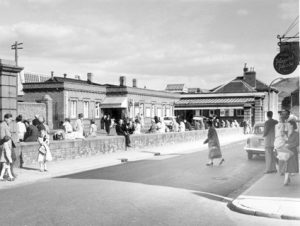
The Low Level, Taff Vale Station, Duke Street. (06cb126 RCT Library Service)
Turn right into Market Street
This short street has much to interest.

Plan of Aberdare Market. Note the many butcher’s stalls ranged around the sides.
The first building on your left, now the New Market Tavern (previously The Cowbridge Arms) formed part of Aberdare’s Market complex, built in 1853; here in 1861 the very first National Eisteddfod of the modern era took place. A heritage blue plaque acknowledges the importance of this event.
Most of the old market was destroyed in a fire on 6th December. 1902, and replaced by the present covered building. A date stone records the date of reconstruction (1903).
The market had its own slaughterhouse, this has been converted into a range of shops. Little changed externally it stands directly opposite the market. The river Dare, culverted since 1871, flows directly behind it, and the river was a depository for the foul detritus of slaughtering.
The private park at the side of the market, shown as Cattle Yard on the above plan, was throughout the nineteenth century the venue for travelling theatres and other shows. It was used by the film pioneer, William Haggar, who toured the industrial valleys of south Wales with a portable bioscope exhibition (early cinema show), wintering in Aberdare.
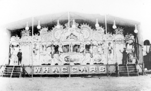
Haggar’s show front ca 1908. Note the Gaviola Organ. Glamorous girls would parade the front to attract an audience. His shows were driven by steam traction engines, Haggar had three; ’Cymru am Byth’, ‘King George V’ and ‘Maid of Cefn Ydfa’. The latter is preserved. (22/108 RCT Library Service)
In 1910 he set up a permanent booth there (Haggar’s, Royal Electric Bioscope) before opening, in 1915, a purpose-built cinema, The Kosy Kinema opposite (now the betting shop). A plaque commemorating Haggar can be seen on the façade of the market.
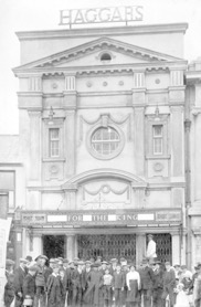
The photograph was taken on the occasion of the Kinema’s opening. Haggar would have filmed the Civic Sunday Parade himself. Six old pence would buy you the comfort of an upholstered armchair. (01l005 RCT Library Service)
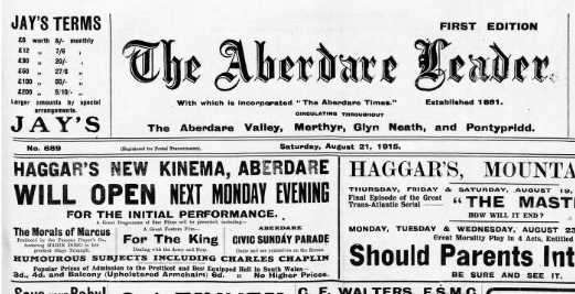
Aberdare Leader, 21st. August, 1915
This whole area was vibrant throughout the nineteenth century especially during the duration of the town’s annual April Fair.
The nightclub, Judges and Jurys, another of the town’s fine secular buildings, stands in Market Street. Built-in a classical style in 1914 as the new Magistrates’ Court, the date of the building is shown in Roman numerals.
The Aberdare Leader was first printed at the Market Buildings, (now called Boot Chambers).
Leave Market Street
Turn right into Cardiff Street. Head towards the Cenotaph. On your right is the former Boot Hotel, once the finest of the town’s inns. This was the second hotel of that name (see below).
The Cenotaph stands at the foot of Victoria Square (Commercial Place until 1887). Located on an island the town’s war memorial was designed by F H Morley of Durham. Made of Dalbeattie granite it was put up in 1927. Resembling Lutyen’s national monument in London it originally memorialised the 800 men of the Aberdare Urban District Council who lost their lives in the First World War. No individual names are recorded on it, but there is a Book of Remembrance at the library. The cenotaph is not, contrary to general public belief, one of only two such named monuments in Great Britain.
Previously a Jubilee drinking fountain, the gift of Sir W T Lewis (Later Lord Merthyr) in 1897 occupied the site.
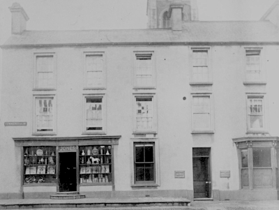
The drinking fountain. The bank (left), now Barclays was The Bailey’s Arms, after Crawshay Bailey. Note the outfitters, Hodges (right). The museum has a fine collection of items relating to this old family business. (33347 RCT Library Service)
A prosperous Commercial Place in its Victorian heyday. Its spaciousness is due to the generosity and planning of Lord Bute who owned the land. The milestone (centre) is now located near the library. (01q031 RCT Library Service)
Turn for a moment into Bute Street
Almost immediately on the right is a tablet recording that it was visited by Queen Mary in 1912, who expressed a desire to see a ‘typical miner’s cottage’.
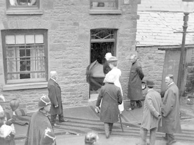
George V and Queen Mary at the Bute Street (number 71) cottage. Coronation tour of the valleys, 1912 (24033 RCT Library Service)
Back on Victoria Square
The three-storey building on the left, now Southern Fried Chicken, was another printing office, that of Josiah Thomas Jones, where Aberdare’s first English language newspaper, The Aberdare Times, was published and printed from 1861.
The square, which still retains its Victorian character, is dominated at each end by the former Boot and Black Lion Hotels. The earliest Black Lion was opened in 1811; it housed the town’s first mail office and was a posting house. In front of this once elegant and bustling hotel stands the statue of Griffith Rhys Jones, ‘Caradog’ by Sir William Goscombe John RA.
Caradog was the conductor of the famous South Wales Choral Union and perhaps epitomises Aberdare’s cultural heritage. Raised stone lettering on the façades of two of the buildings here recalls the area’s former prominence as one of ‘the’ shopping streets of the town. The Beehive and Compton House were large drapery establishments where sewing girls lived in. Quality shops such as these would have attracted the ‘carriage trade’.
Returning to the library
You pass St Elvan’s church with a spire that rises to 180 feet. This fine church, known as the ‘Cathedral of the Hills’, was built between 1851 and 1852. Its interior contains many finely carved ecclesiastical fittings, an impressive parish war memorial, and Victorian stained glass of the highest quality. The bells, eight in number, belong to the town.
Wetherspoon’s was the site of the original Boot Hotel (Boot and Railway after the opening of the Taff Vale line to Aberdare in 1846). The present building was the post office.
The building next to it was St David’s Presbyterian Church. It once had a small steeple. The adjoining roadway leads to Rock Grounds. The present building of 1938 was originally a clinic and later the Council chamber and principal office of Cynon Valley Borough Council. It stands on the site of Rock Brewery, one of several breweries, serving the town. In the 1890s the brewery owner laid out Recreation Grounds to the right of the building, the facilities included a circus and Music Hall (The Empire).
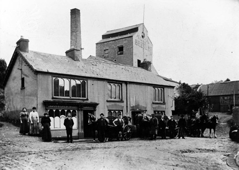
The Black Lion Brewery, the Empire Music Hall can be seen back right. (13b002 RCT Library Service)
The bust on the lawn in front of Rock Grounds is that of Keir Hardie, a founder of the Labour Party and former Member of Parliament for Merthyr Tydfil and Aberdare. (1900-1915)
The course of the river Dare enters a culvert near Rock Grounds flowing underground through the centre of the town, reappearing to merge with the river Cynon at the footbridge crossing the bypass.
An ancient corn mill stood on the site of the lower car park opposite Wetherspoon’s, when the corn mill closed it was replaced by a woollen mill. This in turn was converted to a boot, clog, and shoe factory (Halewood’s). Both the corn and wool mills were powered by the river Dare.
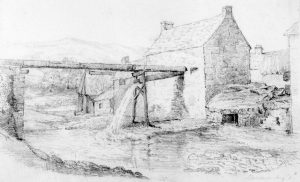
The mill in 1827/8, sketched by one of the Bacon sisters. (ACVMS-1998.3411_001)
The land of the upper car park has been home to cottages, a monumental mason and finally The Rex, an Art Deco cinema.
The natural stone monument, erected by the Cynon Valley History Society, on the St Elvan’s corner of the car park commemorates James James (Iago ap Ieuan) the composer of the Welsh National Anthem, who lived and died in Aberdare. He is buried at Aberdare cemetery.
The offices to the right of the stone, (Graeme John Ltd} was a druggist’s shop (opened 1826), owned by John Jones. The shop became known as Jones, Ceffyl Gwyn (White horse) after the famous image displayed in the window. This and other objects belonging to the business are on display at Cynon Valley Museum. The original curved stone steps, seen below, are still in place. The white horse indicated the shop provided veterinary remedies to the local farming community.
Jones, Ceffyl Gwyn the chemist (01q044 RCT Library Service)
Return to the Library Square
You pass an elaborate milestone, this shows the distances to London, Cardiff, Neath and Brecon. It was set up by the Board of Health in 1860 close to the spot where Caradog’s statue now stands.
Back at the library look towards the higher level car park. This is the site of the Gadlys, or Victoria, pit opened by the Waynes in 1844 to supply ironstone and coal to their Gadlys ironworks. Substantial remains of this stand directly behind the present museum. The colliery headgear was still in place in the 1970s.

Gadlys or Victoria Pit, with Green fach and the town in the right background. (RCT Library Service)
This concludes the walk
When lockdown restrictions are lifted, we highly encourage that you walk the route yourself, and visit the museum to see related objects.
Geoffrey Evans, Cynon Valley Museum Volunteer, May 2020
Further reading
- Wales’ Newspapers archive is available to browse online.
- RCT’s Library Service Archive is digitised and available to browse here.
- Once the Cynon Valley Museum reopens, many items relating to this walk are on display for you to view.
Thanks for reading!
We’re working hard to bring online content to you during this period of uncertainty. You can see some of these on our Exhibition at Home page. If you’d like to support the Cynon Valley Museum during this time, please share this post with your friends and family. You may also like to make a donation. We’re a registered charity and really appreciate your support, we are looking forward to welcoming everyone back to the museum as soon as possible.
Like this?
You might be interested in receiving Y Chwa/The Blast, a quarterly newsletter for the Friends of Cynon Valley Museum, which includes collection highlights, museum news, and similar articles to this. Click here to find out more about the Friends Group.

Thank you so much for sharing this fascinating insight into the history of the town
I get from reading this that nothing existed when you get to the top of Market street of any importance if you were to turn left and not right towards the cenotaph??
Hello Charles,
Thank you for commenting on the town centre walk. Actually there is much of interest in Cardiff Street (turn left on leaving Market Street instead of heading towards the cenotaph and Victoria Square) but the present walk was designed to be a rough circuit of the town centre, rather than a complete tour of Aberdare’s main streets. The walk as
set out takes some 50/60 minutes with a guide.
Here are just three points of note in Cardiff Street:
The location of Evan Thomas’ original lamp works.
The site of the National (church) school of 1829.
The fine architecture of the now closed former Midland/HSCB bank.
Geoff, Volunteer at CVM.
Very good and Thank you
Thank you, that was very interesting. Thoroughly enjoyed reading.
Extremely interesting and informative . My M.A. thesis was based on Aberdare c. 1840-80 . I found the ‘ walk around ‘ concept invigorating .
Excellent I loved all the info on aberdare and the history thank you.
A great discription of the town . what a lovely town please preserve its history . I now live abroad and really love to come home to visit . Thanks to everyone involved for all the work you do .
Thank you so much , i walked every word ,brought back so many memories of my youth and Dads stories of the town ,place names i remember but didnt know why they had their names .
I loved this walk. Thank you. I remember the low level station nd began many a journey there.
My father was born in Aberdare in 1929 and then moved to Essex. I have been there a couple of times the last time to the United Church where my grandparents and great grandparents used to be part of that community. One day again I will return … Thank you for putting this together.
Sorry it is the Unitarian Church Highland Place.
I read this when I should have been doing some work. But I don’t care…it was great and I felt so proud to come from Aberdare.